Beni Hammad Fort, Algeria- Zoefact
Beni Hammad
Fort, also known as Beni Hammad’s Al
Qal’a is an imperial Islamic city, now ruined,
founded in central Algeria during the eleventh century CE (fourth century AH).
It served as the first capital of the Hammadid dynasty in the 11th century. It
is northeast of M’Sila, at an elevation of 1,418 meters (4,652 ft), in the
Hodna Mountains and receives ample water from the surrounding mountains. It is
one of the Islamic civilization’s most interesting and most correctly dated
monumental complexes. Near the town of Maadid (aka Maadhid), about 225
kilometers (140 mi) southeast of Algiers, in the Maghreb, is the Beni Hammad
Fort. After their freedom from the Zirids and the Fatimids of Tunisia, the seat
of the Hammadids was founded by the founder of the Hammadid dynasty, Hammad bin
Buluggin I (reg. 1015-1028 CE / AH 406-419), starting in 1007 CE (AH 397).
The
settlement developed rapidly into a flourishing metropolis and cultural center
from the base of the original qalat, or fortress. In its fortified settlement
in the Maadid mountains, Qalat Beni Hammad attracted commercial caravans,
scientists, musicians, theologians, politicians, and poets. It was the first
capital of the Emirs of Hammad and had great splendor. In 1980, it was
inscribed as a World Heritage Site by UNESCO, and described as “an authentic
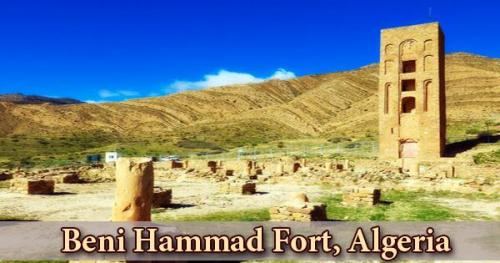
picture of a fortified Muslim city”. Within 7 km of partly dismantled defensive
walls, the Qal’a contains a significant number of monumental ruins, including
the Great Mosque and its minaret, and a number of palaces. The mosque is the
largest after that of Mansourah and its minaret is the oldest in Algeria after
that of Sidi Boumerouane, with its prayer hall containing 13 ships out of 8
bays. The Qal’a Ruins bear witness to the great sophistication of North
Africa’s Hammad civilization, original architecture, and palatial culture.
The primary
source summary of the resident city of al-Bakri (1014-1094 CE / AH 404-487) and
the historical account of Ibn Khaldun (1332-1406 CE / AH 732-808) testify to the military
power of the city as well as its economic and intellectual capital. At the end
of the eleventh century, just before the Hilalian incursions precipitated the
collapse of the town, the town reached the height of its regional importance
during the rule of the later Hammadids. Numerous terracotta, gems, coins and ceramics
that attest to the high degree of civilization under the Hammadid dynasty have
been brought to light by excavations. Several decorative fountains using the
lion as a symbol are also among the discovered artifacts. Three independent
residences divided by gardens and pavilions form the ruins of the emir’s
palace, known as Dal al-Bahr.
The city
became the capital of the Berber Hammadids, and in 1017 it was under siege by the Zirids. It was
abandoned in 1090 under the threat of Banu Hilal and partially destroyed in
1152 by the Almohads. The qalat is located near the peak of Takarbust on the
Hodna plateau, the summit of which was enclosed by a large ring of fortifications
that established the boundaries of the walled city. The average height of the
enclosed city is 990 meters above sea level, while, at its highest point, the
Takarbust peak rises to 1418 meters above sea level.
Many of the
smaller and more modest structures have been lost because of a lack of
maintenance or inhabitation in the centuries since the foundation of the city,
however, there is evidence of some large buildings. Near its longitudinal core,
the mosque is situated in the south of the walled city. The mosque is very
large, with a rectangular plan measuring east-to-west 56 meters wide and
north-to-south 64 meters long. The longitudinal axis of the mosque aligns with
the meridian between the north and the south. At the center of the north wall,
a minaret is located, while public entrances open into the mosque courtyard on
the east and west walls.
Another
architecturally important building inside Qalat Beni Hammad is the Qasr al
Manar, also known as the “Castle of the Beacon Light”. Qasr al Manar is a large
defensive structure at the edge of a cliff overlooking the Hodna plateau to the
south, a fortified projection of the eastern wall of the city. The stone
masonry structure is approximately cubic in size, measuring 30 meters wide from
east to west and 32 meters long from north to south. The fort also includes a
wide reception room at its upper level with a domed ceiling, which opens onto a
rooftop terrace. Though primarily a military structure, during times of peace,
the Qasr al Manar was built to accommodate imperial diplomatic functions.
Scattered
fragments of the eleventh-century building and its decorations have survived
elsewhere in the complex. Carved marble water channels, parts of frescoes
within the palaces, ceramic pottery, marble sculptures, crystal and glassware
are among the artworks. Carved stone friezes, carved stone and plaster
muqarnas, and multicolored tiles made using multiple artisanal techniques are
architectural remnants. In the modern period, the site was identified by the
French historian Méquesse in 1886. In 1908 CE, under the supervision of the French
archaeologist de Beylié, modern excavations of the site were first carried out.
Later excavations were undertaken by Lucien Golvin between 1951 and 1952 CE,
and after 1964 CE under Bourouiba. The 150-hectare Qalat Beni Hammad site was
named in 1980 as a UNESCO World Heritage Centre.
Post Your Ad Here
Comments