How As-Built 3D Laser Scanning Improves Waterfront Development Projects?
Waterfront development projects—including ports, marinas, mixed-use coastal complexes, transportation terminals, flood-resilient infrastructure, and urban waterfront revitalization initiatives—present a unique set of engineering and construction challenges. These projects operate at the intersection of land and water, where existing conditions are often undocumented, constantly changing, and highly regulated.
In this context, as-built 3D laser scanning has become a critical technology for the Architecture, Engineering, and Construction (AEC) industry. By delivering high-accuracy existing condition data, laser scanning improves design reliability, coordination efficiency, regulatory compliance, and construction risk management for waterfront developments.
The Importance of Accurate Existing Condition Data in Waterfront Projects
Unlike inland construction sites, waterfront environments are affected by tidal variations, erosion, settlement, and exposure to corrosive marine conditions. Existing infrastructure such as bulkheads, quay walls, piers, utility corridors, and seawalls may have undergone undocumented modifications over time.
Traditional surveying methods often lack the level of detail required to capture these complex conditions accurately. In contrast, as-built 3D laser scanning provides millimeter-level precision, capturing both visible and hard-to-access elements without physical contact. This accuracy is essential for developing reliable architectural, structural, and civil design solutions.
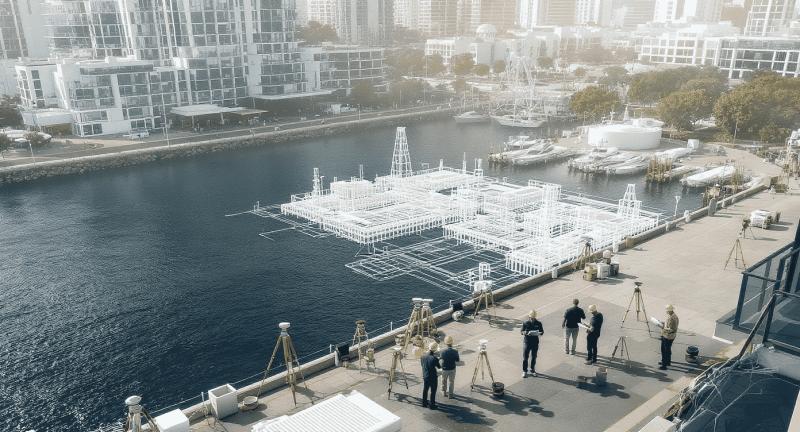
As-Built 3D Laser Scanning: A Reality Capture Standard
As-built 3D laser scanning uses LiDAR technology to collect millions of spatial data points that represent the true geometry of existing assets. The resulting point cloud data forms a digital record of structures, terrain, and surrounding conditions.
For waterfront developments, scan data typically includes:
-
Shoreline geometry and elevation data
-
Existing buildings and marine structures
-
Substructure interfaces between land and water
-
Mechanical and utility systems exposed within facilities
This data can be processed into CAD drawings, BIM models, or digital twins, supporting downstream design and construction workflows.
Supporting Integrated AEC Design Coordination
Waterfront projects require close coordination among multiple disciplines, including architecture, structural engineering, marine engineering, geotechnical engineering, and environmental planning. Any discrepancy between existing conditions and design assumptions can lead to costly delays and change orders.
By integrating as-built scan data into BIM environments, project teams establish a single source of truth. Architects and engineers can design directly within verified spatial constraints, reducing design clashes and improving interdisciplinary coordination. This approach aligns with modern AEC best practices for collaborative project delivery.
Improving Constructability and Reducing Field Risk
Constructability challenges are common in waterfront developments due to restricted access, staging limitations, and environmental constraints. Laser scanning supports constructability analysis by enabling accurate evaluation of clearances, alignments, and tolerances before construction begins.
Contractors can use scan-based models for:
-
Prefabrication planning
-
Installation sequencing
-
Equipment access verification
-
Quality control and verification
This proactive use of as-built data significantly reduces on-site rework and safety risks.
Regulatory Compliance and Documentation Standards
Waterfront developments are subject to strict regulatory oversight related to flood zones, coastal management, environmental impact, and public safety. Regulatory authorities often require accurate, verifiable documentation of existing conditions before approving design modifications.
As-built 3D laser scanning provides defensible documentation that supports:
-
Permit applications and approvals
-
Environmental impact assessments
-
Floodplain and elevation studies
-
Compliance with local and federal regulations
The precision and traceability of scan data make it well suited for meeting regulatory documentation standards.
Enabling Efficient Renovation and Adaptive Reuse
Many waterfront projects involve redevelopment of aging or underutilized infrastructure. Renovating marine structures without accurate as-built information increases the risk of unforeseen conditions and design conflicts.
Laser scanning captures the true geometry of existing assets, allowing design teams to develop accurate retrofit and reinforcement strategies. This reduces uncertainty during construction and supports informed decision-making during adaptive reuse projects.
Long-Term Asset Management and Lifecycle Value
Beyond design and construction, as-built 3D laser scanning contributes to long-term asset management. Scan-derived BIM models can be used by facility managers to track asset conditions, plan maintenance activities, and manage future upgrades.
For waterfront assets exposed to harsh environmental conditions, having an accurate digital record supports proactive maintenance strategies and extends asset service life.
Supporting Climate Resilience and Coastal Planning
Waterfront developments must increasingly address climate-related risks such as sea-level rise, storm surge, and erosion. High-resolution scan data provides detailed elevation and spatial information that supports resilience planning and mitigation strategies.
This data enables engineers and planners to evaluate vulnerabilities and design infrastructure that meets modern resilience and sustainability objectives.
Conclusion
As-built 3D laser scanning has become an essential tool for improving the planning, design, and delivery of waterfront development projects. By providing accurate existing condition data, supporting integrated BIM workflows, enhancing constructability, and ensuring regulatory compliance, laser scanning aligns with current AEC industry standards and best practices.
As waterfront infrastructure continues to evolve in response to urban growth and climate challenges, as-built 3D laser scanning will remain a foundational technology for delivering safe, resilient, and efficient coastal developments.
Post Your Ad Here
Comments