What Are Drone Surveying And Aerial Mapping?
In modern mapmaking and analysis, drone technology has created a prominent transformation. Drones have been a bonus for surveying and mapping applications, especially when getting into the details of imagery. Drones can fly and generate images at the same time. In this article, we will explore, through Aerial Surveying and Mapping, the importance of drones in mapping and how they are applied.
The Basics Concept Of Drones
Drone surveying is an application that is now being advanced in geospatial technology. Where drones are used to capture imagery and gather information from the land, they are upgraded with the latest optics and infrared sensors. In this way, they provide precise pictures and measurements. Through the use of GPS, drones can travel to various regions. And can provide photos of different viewpoints from above. The data is used to develop height and surface properties maps from here. Drones use aerial surveying in the modern way of the data acquisition process. The required gathering of the information is not done manually from the field.
What Is Aerial Mapping
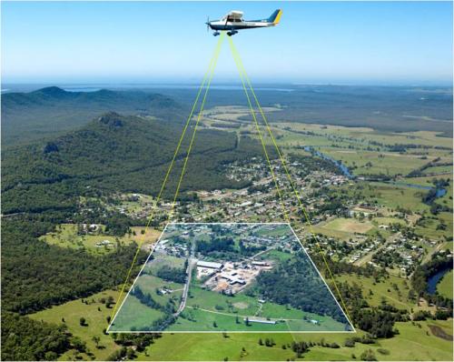
Through aerial tools, unique cameras on drones or planes take bundles of images from the sky. Among them, some appear to be neighboring or overlapping. Others showcase the exact location captured by different points. Consequently, image processing programs that combine these pictures are used. They are used to develop high-resolution maps and 3D models. It’s like a puzzle with the pieces of the image in place. And taking separate ones to solve the picture’s challenge. With aerial mapping, we acquire knowledge about the Earth’s surface, city planning, and the use of natural resources. This is done in a much improved and accurate manner by the use of aerial mapping.
Advantages Of UAV Surveying And Aerial Mapping
Cost-Effectiveness
For some applications, drone surveying is more viable in terms of expenses. Since it involves some staff and equipment.
Rapid Data Collection
Drones can cover large areas in a fraction of the time. Thereby enabling rapid data acquirement and problem-solving.
Accessibility
A drone can be accessed on-site or in remote areas. Therefore, it is suitable for mapping complicated lands or disaster places.
Safety
Drones save a person from being exposed to hazardous environments. Consequently, it reduces the chance of accidents and injuries. You can take this everywhere without being there by yourself.
Flexibility
UAVs can have different types of sensors and payloads, covering most areas, such as environmental monitoring, construction site management, or agricultural mapping.
Drone Surveying In Action
Let’s start with an example. Some workers have a construction project and must survey a big area. They have to do some investigations. So that the engineers will be able to plan where the infrastructure will be developed. The newcomers in the field use drones with high-resolution cameras and LiDAR sensors rather than those on the ground that were flawed in the past. The drones, in that case, fly autonomously over the survey site. They will collect very high-resolution and more accurate elevation data. At the office, complicated programs process this data to produce exacted 2D maps and 3D scale models. And topographic atlas of the zone. Based on the data, the engineers will work on plans for roads, buildings, and drainage systems. In this way, they could make maps with accuracy and effectiveness.
The Role Of Aerial Targets In Drone Mapping
In drone surveying and aerial mapping, the accuracy of needed things is critical. 48 “aerial targets, also called ground control points, aid in achieving accuracy. They act as reference points in the georeferencing of aerial acquired images. These targets are typically put uniformly across the survey area. Each captured image can be precisely aligned with a given geographic coordinate. With 48”x48” aerial targets, we can guide a drone on what to do and where. So that every place is addressed while gathering data.
Conclusion
In summary, drone surveying and aerial map generating are the latest technology. It shows more potential for obtaining and processing spatial data from the field of view. Thanks to the fantastic flexibility, power, and precision that drones can provide. Drones are becoming an essential tool for companies and applications in the industry. The era of unmanned aerial vehicles was a limited exploration in the past. Now, it is slowly becoming a gateway to a new era of discovery and exploration.
Post Your Ad Here
Comments