CATSURVEYS- Network Rail Great Western Electrification Scheme
Utility detection survey combines a record of underground utility
lines with key topographic features. Utility mapping doesn't require any
additional digging up of the roads; it's all done from the surface using GPS
and radio detection techniques.

Utility mapping ensures the efficiency of operations and that all
vital services can still be delivered: or at least, that any necessary
interruption can be planned for and minimised. Utility detection surveys might
also form part of the initial stages of construction work. Many development
projects may require you to undertake utility mapping as part of the initial
feasibility study; the feasibility of a new multi-storey car park may be greatly
affected if the job will call for the diversion of a major water main or the
rewiring of a town centre's electrical grid.
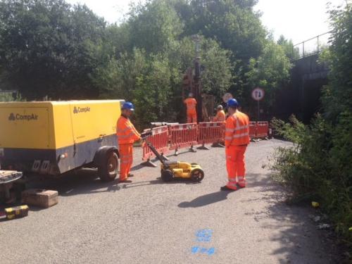
CATSURVEYS have been busy carrying-out Utility
Surveys and bore hole works from London to Swansea including the M4
corridor for an SSE/ Murphy’s project, to design horizontal directional
drilling profiles for Network Rail Great Western electrification schemes. This
is the biggest investment for the Great Western Railway since it was originally
built by Brunel over 150 years ago. This immense project will bring faster,
greener and more reliable services across the South West region with the help
of new high speed electric trains, signal improvements along with Cross rail services
from Maidenhead into London; giving the commuter a more comfortable, smoother
and quieter journey.

About
Company: Cat Surveys is based in Essex and uses various techniques and equipment such
as Electromagnetic Locators (EML) and Ground Penetrating Radar (GPR) to
accurately identify underground features and utility apparatus to locate Utility Mapping Essex.
For
More Details Please Visit: http://www.cat-surveys.com/