How Scan to BIM Turns Reality into Ready-to-Use 3D Models
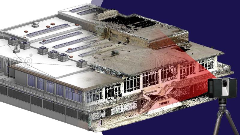
Scan to BIM is a foundational workflow driving digital transformation in the AECO industry. It starts with 3D laser scanning or LiDAR technology to capture the physical site at high resolution and accuracy. These technologies gather millions of spatial measurements, creating point cloud data that precisely represents real-world conditions. This digital capture allows professionals to convert existing structures into parametric 3D models, which serve as the backbone of Building Information Modeling. The result is a highly detailed, information-rich representation supporting all phases of project lifecycle management, from design through operations.
The strength of Scan to BIM lies in improving coordination and minimizing downstream issues. Accurate point cloud interpretation enables teams to establish a reliable modeling sequence—starting with reference levels, then structural elements, followed by Mechanical, Electrical, and Plumbing systems. This approach reduces the risk of design conflicts and costly rework. When paired with middleware tools like Cintoo Cloud or PointCab, the workflow scales efficiently across large or complex projects. Scan planning can also support phased modeling strategies, building models incrementally to meet project milestones and required accuracy.
Scan to BIM enhances collaboration across BIM maturity levels, from Level 0 (basic 2D CAD) to Level 3 (integrated, open Common Data Environment). By capturing verified site conditions and sharing data through cloud-based platforms, teams perform early-stage clash detection, simulate virtual installations, and maintain digital record keeping long before construction starts. This integrated process lowers risks, reduces change orders, and strengthens safety management. As software like Autodesk Revit, FARO SCENE, and Leica Cyclone evolve, Scan to BIM continues to bridge physical environments and actionable digital models.
What Is BIM?
Building Information Modeling is a data-centric process for planning, designing, constructing, and managing buildings and infrastructure throughout the project lifecycle. It revolves around parametric 3D models that store geometric properties and metadata for every building component. These models enable real-time coordination between architecture, engineering, construction, and facility management teams. BIM automates changes—modifying one element updates all related drawings and schedules instantly. Tools like Autodesk Revit support simulations, clash detection, quantity extraction, and digital documentation, enabling faster decisions and higher quality outcomes. Sharing BIM models through a Common Data Environment allows all stakeholders to work from validated data, reducing risk and improving accuracy across renovation, retrofit, and new construction projects.
BIM Collaboration Levels
- Level 0: No collaboration; unmanaged file sharing with only 2D CAD drawings.
- Level 1: Partial collaboration; managed CDE with mixed 2D and 3D CAD files.
- Level 2: Full multidisciplinary collaboration; shared BIM models with coordinated geometry, cost, and scheduling.
- Level 3: Integrated project delivery; open BIM with real-time data exchange and full digital integration.
Features to Look for in a Laser Scanner
Resolution and Accuracy
Resolution defines the detail level of captured surface geometry, while accuracy measures how closely scan data matches real-world dimensions. High resolution and accuracy are essential for reliable point cloud interpretation and detailed parametric 3D model creation.
Range Performance and Working Distances
Matching scanner range performance to project scale supports operational efficiency. Consider the maximum working range, minimum range, and real-world performance under site conditions such as dust, reflective surfaces, and lighting.
Field Workflow Features
Advanced field features enhance scanning efficiency and data quality:
- Inclination sensors aid in tilt detection and scan alignment.
- Integrated cameras provide colorized images for better visualization.
- Automated registration speeds scan alignment on-site.
- Real-time feedback alerts operators to data gaps or quality issues.
Hardware Considerations
Durability and reliability matter in dynamic environments. Evaluate battery life for full-day scanning, environmental resistance to dust and moisture, and quick setup time to optimize fieldwork.
Popular Brands and Models
Top manufacturers trusted in Scan to BIM workflows include:
- Leica Geosystems (BLK360, RTC360, BLK2GO)
- FARO (Focus series)
- Trimble (X7)
- GeoSLAM (ZEB series)
Scan to BIM Process Workflow
Step 1: Data Acquisition
Technicians collect high-density point cloud data using 3D laser scanning or LiDAR devices selected for resolution, range, and field workflow capabilities.
Step 2: Point Cloud Preprocessing
Raw data is cleaned, downsampled, and aligned using software such as Leica Cyclone or FARO SCENE to manage data density and occlusions.
Step 3: Point Cloud Interpretation and Modeling Approach
Modelers analyze spatial data and choose between literal geometry, parametric approximation, or hybrid methods. The modeling sequence follows reference levels, structure, MEP systems, and architectural details.
Step 4: BIM Model Development
Parametric 3D models are built using Autodesk Revit or similar tools, integrating point clouds with middleware like Cintoo Cloud or Scan Essentials.
Step 5: Model Validation and Delivery
The BIM model undergoes quality verification, including tolerance checks against point cloud data, supporting clash detection, prefabrication, and facility management. Final outputs are delivered for the next project phase.
Challenges in Point Cloud Data Integration
- Large datasets can slow processing and require careful downsampling to retain critical details.
- Occlusions and blocked areas cause missing data, complicating model accuracy.
- Complex architectural features increase modeling time due to manual intervention.
- Poor scan planning leads to incomplete or unusable data sets.
- Lack of continuous quality verification risks discrepancies between point clouds and BIM models.
- Environmental noise from weather or lighting must be filtered to prevent errors.
- File incompatibilities disrupt smooth data workflows.
- Site accessibility and interruptions for recharging reduce scanning efficiency.
Applications and Benefits of Scan to BIM
Integration with Advanced Technologies
Scan to BIM incorporates Virtual Reality and Augmented Reality for immersive walkthroughs and enhanced stakeholder engagement. Digital record keeping leverages parametric 3D models to support project lifecycle management from design through facility management. Mobile LiDAR and remote robotic scanning expand data capture capabilities in hazardous or difficult environments, improving safety and coverage. These technologies enhance accuracy, enable real-time collaboration, and support risk reduction throughout Scan to BIM workflows.
Best Practices and Execution Plan for Scan to BIM
- Adopt Scan to BIM early in all project phases for consistent integration and accuracy.
- Define project-specific Level of Detail to balance cost, precision, and usability.
- Coordinate scan planning with BIM modeling requirements to achieve full site coverage.
Perform regular model updates and clash detection to identify and resolve conflicts early.
Conclusion
Scan to BIM transforms physical reality into ready-to-use parametric 3D models, bridging 3D laser scanning data with intelligent Building Information Modeling. This process enhances collaboration across AECO teams by using point cloud data and digital record keeping. It reduces risks, change orders, and costs while supporting full project lifecycle management. Integrating Scan to BIM improves accuracy, enables advanced applications like clash detection and virtual installation simulation, and drives better facility management and renovation outcomes. Adopting Scan to BIM is essential for achieving superior project results in today’s digital construction landscape.
Post Your Ad Here
Comments